Introduction
Accurate solar radiation datasets are required at all stages of development and operations of a solar generation facility. In most cases solar radiation measurements using ground-based instruments are only available on-site for about a year before a project receives financing. As solar resource varies significantly on an annual basis, understanding the inter-annual variability and collecting data for multiple years is important since the variability could range in the order of 5%-10% for Global Horizontal Irradiance (GHI) and up to 15% for Direct Normal Irradiance (DNI)(Gueymard & Wilcox, 2011).
Various stage of solar energy projects as shown in Figure 2 have different data requirements. As can be seen in this figure from the Solar Resource Handbook (Sengupta et al., 2017) all stages of a project require modeled solar resource information.
(A) Prefeasibility
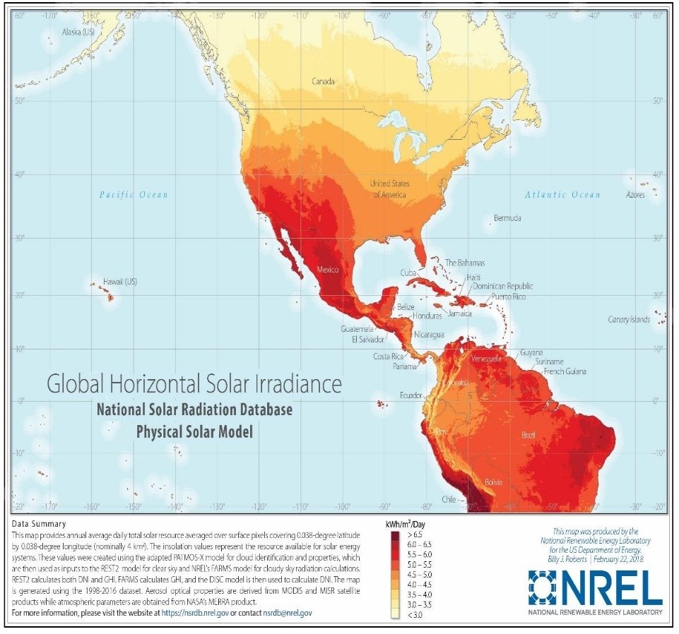
For the four steps of a project, prefeasibility studies which is at the early stages of project development, have the lowest data requirement. For these studies, solar resource maps depicting regional long-term annual means which can provide a rough estimation of the expected solar resource are considered (e.g., Figure 7). Maps providing monthly or seasonal information if available can enhance the accuracy of prefeasibility studies and can provide additional important information such as matching of load and generation. While long-term ground measurements would be ideal, there is a need for modeled data as ground measurements may not be available regionally. The modeled data should be available for multiple years and preferably over at least a 10 year period. These datasets can be obtained from various sources as described in Chapter 5 of (Sengupta et al., 2017). Normally prefeasibility studies have a goal of determining whether there is sufficient resource availability on a consistent basis, as shown by multiple years of modeled data. As mentioned above, the temporal resolution of the data should be annual values at a minimum and spatial resolution of the datasets can be tens of kilometers unless the location has significant terrain impacts on the resource. Additionally, the uncertainty in the datasets may be higher than in later stage of the project but should be reasonably representative of the location being considered. In most cases the most recent data may not be needed. The multi-year modeled data at regional scale is analyzed to determine the availability of annual solar resource. Prefeasibility studies are used for determining viable technologies and whether subsidies are required to make the site viable.
Minimum or recommended values for the relevant specification items:
- Spatial resolution: better than 10 km.
- Region covered: country or state.
- Solar radiation variables included: GHI, DNI.
- Accuracy / uncertainty of the solar radiation: <10%.
- Time period: long-term.
- Extended variables: not needed.
| Users | ||||||||
| Proyect developers needs at diferent plant stages | Other users | |||||||
| Category of product service | (A) Pre-feasibility | (B) Feasibility & Design | (C) Due Diligence Financing | (D) Plant Accep-tance Test | (E) Systems or Plant Operations | (F) Grid operators | (G) Policy makers | (H) Education / Outreach |
| MODELED SOLAR RADIATION AND METEOROLOGICAL PARAMETERS | ✅ | ✅ | ✅ | ✅ | ✅ | ❌ | ✅ | ✅ |
|---|---|---|---|---|---|---|---|---|
Modeled Solar Radiation series
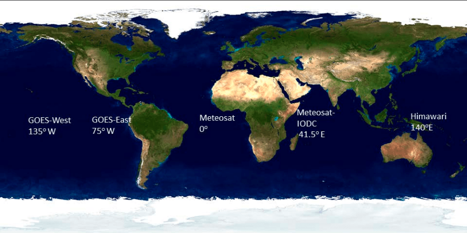
It is known that the ground measurement stations are scarce, on the other hand, geostationary meteorological satellites have been available for most locations on the globe for periods of over 10 and sometimes 20 years (Figure 6). As these satellites have the necessary channels to sense and measure cloud properties and other meteorological datasets, they have been used extensively to model solar radiation over the long-term. These satellites provide data at high temporal (5 minutes to hourly) and spatial (2-5 km) and complement the short-term solar measurements taken on-site. Similarly, the ground solar measurement data can be used for site adaptation to remove biases in the satellite data. Details about the ground measurements and satellite derived dataset is described in Chapter 6 of (Sengupta et al., 2017).
While solar radiation is the most important variable information, additional meteorological variables are required to model electric generation using various technologies such as photovoltaics and solar thermal technologies. Some of the meteorological parameters such as temperature, humidity, pressure, wind-speed and surface albedo are important. As these parameters are not regularly measured on a long-term basis at prospective sites modeled datasets form an important component of the requirements for solar generation modeling. These modeled data can derived from reanalysis datasets such as Modern-Era Retrospective Analysis for Research and Applications, version-2 (MERRA-2) from NASA(Gelaro et al., 2017); North American Regional Reanalysis (NARR)(Mesinger et al., 2006); Climate Forecast System Reanalysis from the National Center from Environmental Prediction (NCEP) and ERA-5 from the European Center for Medium Range Weather Forecasting (ECMWF).
The relevant features for the modeled solar radiation and meteorological parameters are:
- Spatial resolution. It is related with the grid size. Depends mainly on the data source for the estimation.
- Region covered. Usually, cover continents, countries, or specific zones.
- Solar radiation variables included.
- Accuracy / uncertainty of the solar radiation.
- Time resolution.
- Time period.
- Extended variables.