Introduction
The direct normal component of the solar resource is variable in time and space. The value of the DNI incident on a site varies throughout the day and depends on the climate of the location. Its value has a deterministic and a stochastic component. The deterministic component is caused by the apparent daily motion of the sun in the sky and the Earth-Sun distance. This component can be calculated by means of the Earth-Sun geometrical equations. The stochastic and less predictable component is caused by several agents but the main one is the motion of the clouds. Clouds have a stochastic behavior difficult to forecast at high temporal resolutions. In the absence of clouds, the atmospheric components such as aerosols also have an influence, although these parameters are slowly varying and do not significantly influence solar radiation at high temporal resolutions. Both agents are dependent on the climatic features of the area and, for high resolutions, on the microclimatic features of the location. So, the variability of the DNI could be quantified through estimating dispersion during a specific period (temporal variability) or over a specific area (spatial variability).
The variability can be expressed as the coefficient of variation (COV) for variables having a normal distribution, as the variance for any other known statistical distribution, or as the interquartile range when the distribution is unknown. COV is obtained by dividing the standard deviation by the mean of the population or sample (Sengupta et al., 2017).
(A) Prefeasibility
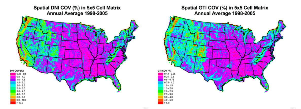
In most countries, the available solar resource information is limited. So, it is common that no on-site data is available or, if so, the data is of low-quality or does not cover a long enough time period. The knowledge of the spatial variability in the area of interest helps to assess the suitability of datasets from nearby locations. In areas with low spatial variability, measurements from a nearby station could possibly represent the solar resource at the selected site, avoiding the need for additional measurements to extend the dataset, filling gaps (Moreno-Tejera et al., 2015) or, even, representing the location (Moreno-Tejera et al., 2016) when no on-site data are available. In these cases, the distance to consider a station close to the site could be considered between 10 and 50 km depending on the spatial variability value (Sengupta et al., 2017). The spatial variability can be quantified by the annual DNI COV of an area and is commonly estimated by means of geographic information system (GIS) solar resource layers or annual DNI maps.
The value of the spatial variability of an area depends on the weather that is related with the climate and the orography of the terrain. A study developed by (Gueymard & Wilcox, 2011; Aron Habte et al., 2020) about the spatial variability of years of data (1998–2005 and 2017 respectivelly) from the U.S. showed that variability tends to be higher in coastal areas and in mountainous areas. Furthermore, the study also reveals that in locations of significant variability, most of the variability occurs over short distances. In these locations, complementary information, as spatio-temporal mean annual variability metrics, helps to evaluate the adequacy of the use of measurements from a location some distance away.

The recommended features for the solar radiation variability for this application are the following:
- Solar radiation variables for the variability assessment: DNI and GHI.
- Time resolution: annual.
- Spatial resolution: 5 km.
- Period of records: >10 years.
| Users | ||||||||
| Proyect developers needs at diferent plant stages | Other users | |||||||
| Category of product service | (A) Pre-feasibility | (B) Feasibility & Design | (C) Due Diligence Financing | (D) Plant Accep-tance Test | (E) Systems or Plant Operations | (F) Grid operators | (G) Policy makers | (H) Education / Outreach |
| SOLAR RADIATION VARIABILITY | ✅ | ✅ | ✅ | ❌ | ❌ | ✅ | ✅ | ✅ |
|---|---|---|---|---|---|---|---|---|
DNI variability maps
In the context of a Solar Energy project, the spatial variability of the DNI is mainly used in the pre-feasibility stage to assess the suitability of datasets from nearby locations when a quality dataset on-site is not available.
Time series variability
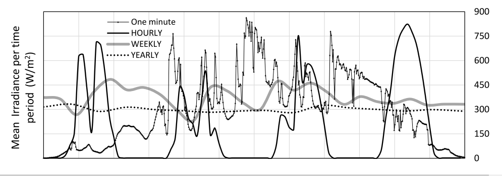
The time variability is used in different stages of the project and for different time resolutions, from annual to daily resolution. As the stages of the project progress, the resolution of the variability evaluated increases. Figure 9 shows how the variability of a GHI time series at a North American location varies depending on the integration time (Perez et al., 2016).

The relevant features for the solar radiation variability are:
- Solar radiation variables for the variability assessment.
- Time resolution (from annual to hourly).
- Spatial resolution.
- Period of records.

